
The Mach Loop: Your Chance to Peer into the Cockpit of a Speeding Jet
Introduction
Tucked between Dolgellau to the north and Machynlleth to the south lies the Mach Loop, a series of steep-sided valleys in central Wales used by NATO air forces for low-altitude training. Pilots execute high-speed manoeuvres as low as 250 feet above ground, turning these Welsh hills into a living Top Gun simulator. Enthusiasts and photographers flock here for a front-row seat to jets roaring through narrow gaps, making the Mach Loop one of the world’s most thrilling aviation hotspots.
The Valleys and Flying Area
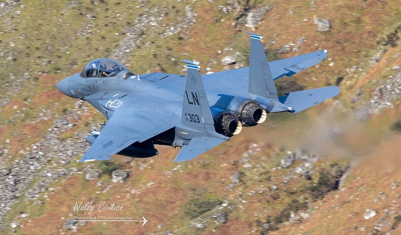
The Mach Loop sits within Low Flying Area 7 (LFA 7), one of the RAF’s designated tactical training zones in the UK. LFA 7 covers most of Wales and permits military aircraft—Typhoons, Hawks, A400Ms, F-15s, F-35s, Hercules and more—to practice terrain-masking and rapid-turn drills. The valleys’ natural amphitheatres offer spectators exceptional views, while pilots refine combat-relevant skills under real-world conditions.
Top Vantage Points
The Loop’s fame rests on a handful of prime viewing sites, each offering a distinctive perspective on passing aircraft. Many of these locations are on private land—please respect farmers’ access gates and take all litter home.
Bluebell
A steep 300-foot climb from the A470 lay-by leads to a narrow shelf with direct head-on and side-profile views of jets slicing through the valley. Light is best before noon, and stable footwear is essential for the rocky ascent.
Bwlch (Lower & Upper)
Located on the A470, Bwlch features two tiers: Lower Bwlch (60 m climb) for side-on passes and Upper Bwlch (120 m climb) for elevated, topside shots. Photographers praise its uninterrupted backdrop of rolling Welsh hills.
Cad East
Accessible via a 1 km footpath or a farmer’s track open to early-birds, Cad East delivers belly-and-wing-aspect views as jets bank beneath viewers. Expect a 120-metre climb and limited parking atop the hill—arrive at dawn to secure a spot.
Cad West
A shorter 750-m trail from the roadside parking leads to Cad West, offering dramatic topside perspectives in the afternoon. The hill levels out at 90 metres, making it suitable for anyone comfortable with a moderate hike and long lens gear.
Corris Corner
Perched above the Rhiw Gwgan road, this spot requires an 80-m climb via a gated path. Jets banking sharply to follow the valley’s bend appear just feet away, creating heart-stopping photographic opportunities.
Corris Craft Centre (No Climb)
With flat access from the centre’s free parking, this dog-friendly venue provides ground-level views through a natural valley window. It lacks top-down angles but compensates with comfort, on-site café and historic mine attractions for non-fly-by moments.
Tracking Aircraft Movements
There is no public “Mach Loop timetable.” Flight schedules change daily with training needs and maintenance. However, two tools help predict activity:
- RAF Operational Low Flying Timetable: The Ministry of Defence publishes a weekly schedule for all three UK tactical training areas, including LFA 7—but it does not guarantee Mach Loop movements. Tailor your visit around weekday slots in LFA 7 for the best odds.
- Radio Scanners & Online Trackers: Enthusiasts monitor military frequencies—128.700 AM (London Military Central) and 278.000 AM (NATO Low Level)—to catch inbound calls. ADS-B aggregators like 360 Radar or ADSB Exchange also flag transiting jets, helping you know when to train cameras on the valley mouth.
Social-media groups such as “Mach Loop for Newbies” on Facebook share real-time reports of recent sightings, aircraft types and peak times. Follow these to stay in the loop—and please credit spotters when reposting their updates.
Weather and Flying Conditions
Weather governs the Loop’s rhythm. Military doctrine mandates that low-level sorties only occur in fair visibility—flights taper off in heavy rain, low cloud or strong winds. Late spring through summer weekdays generally see the highest activity, as squadrons capitalise on longer daylight and stable conditions.
Photographers gain most from:
- Clear Skies: Sharp jet outlines against blue amplify contrast.
- Dramatic Clouds: Light filtering through breaks casts dynamic shadows on valleys.
- Wind Direction: Light winds minimise camera shake on ridges; avoid peak gusts.
- Temperature Inversions: Warm air trapped under cooler layers can obscure lower passes.
Before you set off, check the Met Office local forecast for Machynlleth and RSPB Dinas—both feed MachLoop.co.uk’s weather page. Dress in layers: mountain conditions can swing from sunshine to drizzle within minutes.
Planning Your Visit
- Timing: Aim for mid-week mornings or afternoons when military traffic peaks. Avoid weekends and Bank Holidays—aircraft seldom fly then.
- Gear: A telephoto lens (300–600 mm) on a sturdy tripod captures tight passes; a handheld monopod suits rapid-fire follow-ups.
- Logistics: Pack food and water—there are no shops or toilets on the hillsides. Apps like Ordnance Survey Outdoors give offline maps of footpaths.
- Respect: Stay on public rights-of-way or authorised paths. Close any gates you pass and leave no trace to safeguard continued access.
Local accommodations—from camping at Cwmrhwyddfor Farm to self-catering cottages near Corris—offer early starts without the drive. Book well in advance during summer or airshow weekends.
Conclusion
The Mach Loop is a singular blend of natural grandeur and the raw power of military aviation. Whether you’re chasing the sonic roar of a Typhoon or the grace of a Hawk T2, the Loop’s valleys reward patient planning, weather-watching and respect for the land. By mastering vantage points, tracking tools and environmental cues, you’ll transform a chance visit into an unforgettable chapter in your aviation-spotting chronicles.
To find out more, check out the Mach Loop listing.
Photo credit: wallycacsabre
References
- “LFA7 – The Mach Loop Spotting Guide,” spotterguide.net, July 23, 2020.
- “Mach Loop – UK Low Level Flying by Military Aircraft,” MachLoop.co.uk.
- “Mach Loop Viewing Locations – A comprehensive guide to the Machloop,” MachLoop.co.uk/category/viewing-locations/.
- “Mach Loop The Official Guide – Where, When and How,” Shootsmart.co.uk.
- “Military low flying: RAF operational low flying training timetable,” gov.uk, updated July 24, 2025.